What the River Knows: Waterways as Living Archives

Marcus Webb
Writer
The Thames is low on a Tuesday afternoon in November, and Lara Maiklem is walking on the foreshore near Blackfriars Bridge with her eyes on the mud. The mud is the color of dark chocolate, slick and dense, studded with fragments of clay pipe stems, shards of medieval pottery, and the occasional oyster shell — remnants of the thousands of years of human activity that the river has swallowed, churned, and periodically returned. Maiklem is a mudlark, a practitioner of the ancient art of scavenging the Thames foreshore at low tide, and she is scanning for objects the way a birdwatcher scans a treeline: with practiced, peripheral attention, letting the eye catch on anything that does not belong to the geology. Within twenty minutes, she has found a fragment of Delft tile, a hand-forged iron nail, and a small glass bottle with a pontil mark that dates it to the eighteenth century. The river gave them up overnight, tumbled them from the bank where they had been embedded for centuries, and deposited them on the surface for anyone patient enough to look. This is what untold history travel looks like along the Thames — not a visit to a museum but a conversation with a river that has been collecting artifacts since before London existed.
Rivers are the oldest archives on earth. They predate every city built on their banks, every language spoken along their shores, every empire that claimed them as borders or highways. The Nile has been flowing for roughly thirty million years. The Thames, in its current channel, for about half a million. The Mekong for perhaps fifty million. Human civilization, in its entirety, occupies a sliver of this timescale so thin as to be nearly invisible. And yet rivers have been our most intimate companions since the first settlements — providing water, food, transportation, defense, and, crucially, a place to discard things. The riverbed is where the broken and the lost accumulate, century after century, creating a continuous, unedited record of human presence that no written archive can match.
The Thames: London's Unconscious
The Thames is the most extensively mudlarked river in the world, and the objects it yields constitute an accidental museum of London's entire history. Roman coins and medieval pilgrim badges. Tudor leather shoes and Georgian clay pipes. Victorian dolls' heads and Edwardian medicine bottles. World War II shrapnel and Cold War telephone components. The river does not curate. It does not privilege one era over another. It simply holds what was given to it and returns it on its own schedule, governed by tides and currents and the slow erosion of the embankment.
The practice of mudlarking dates to the eighteenth century, when the poorest Londoners scavenged the foreshore for anything saleable — coal, rope, copper nails, bones for the glue factories. Today's mudlarks are licensed by the Port of London Authority, and their finds are reported to the Portable Antiquities Scheme, contributing to an archaeological record that grows richer with every tide. The most significant finds — a Bronze Age tool, a Roman cavalry sword, a medieval papal seal — end up in the Museum of London. But it is the ordinary finds that tell the deeper story: the thousands of clay pipe stems, each one representing a single moment when a dockworker or sailor or merchant drew smoke and flicked the broken stem into the water. The river holds millions of these moments, each one trivial, their accumulation profound.
Mudlarking is not excavation. You do not dig. You walk the foreshore at low tide — a window of roughly two hours on either side of the tidal minimum — and you look at what the water has exposed. The experience is meditative, almost trance-like: the constant scanning, the soft squelch of mud, the city roaring above you on the embankment while you walk in the strange, liminal space between water and land. The Thames foreshore is the hidden gems travel experience of London — not a secret, exactly, but a dimension of the city that most visitors never encounter, a place where history is not narrated but physically present, lying in the mud at your feet.
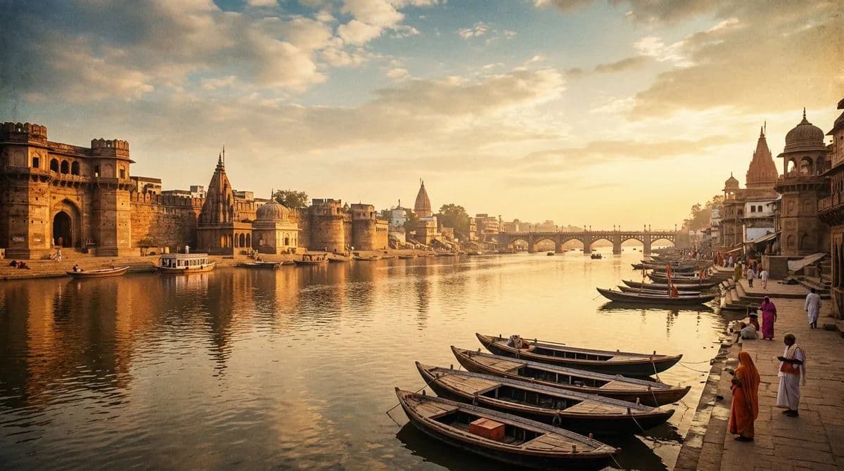
The Ganges: River as Sacred Text
If the Thames is an accidental archive, the Ganges is a deliberate one — a river that billions of people have consciously used, for thousands of years, as a repository of spiritual intention. The cultural landscape exploration of the Ganges is unlike any other waterway on earth because the river is not merely a geographical feature. It is, in Hindu cosmology, a goddess — Ganga Ma, Mother Ganga — and every interaction with it is an act of devotion.
At Varanasi, the oldest continuously inhabited city in the world, the Ganges is the axis around which all life revolves. The ghats — the stepped stone embankments that line the river for seven kilometers — are simultaneously laundry facilities, bathing platforms, cremation grounds, and temples. At dawn, thousands of bathers descend the steps to immerse themselves in water they consider sacred, performing ablutions that have been continuous at this site for at least three thousand years. The ritual is invariant: face the rising sun, cup the water, pour it back. The river receives the offering and carries it downstream, along with the ashes of the cremated, the flowers of the faithful, the clay lamps of the evening aarti ceremony, and the accumulated prayers of a civilization.
The Ganges is a living archive in a different sense than the Thames. It does not preserve objects — the volume of water, the tropical climate, and the biological activity make the Ganges an extraordinarily efficient decomposer. What it preserves is practice. The rituals performed at Varanasi's ghats today are essentially identical to those described in texts written more than two thousand years ago. The river has changed course, risen and fallen, flooded and retreated. The rituals have not. The archive here is not material but behavioral — a continuous performance of devotion that has been rehearsed every morning for a hundred generations, with the river as both stage and witness.
For the traveler, the experience of the Ganges at dawn is one of the most overwhelming sensory events available on earth. The scale is vast — hundreds of ghats, thousands of bathers, the smoke of cremation fires rising along the shore. The sound is complex: temple bells, chanting, the splash of water, the hum of diesel generators powering the lights of the evening ceremony, the cries of boatmen offering rides. And the emotional register is one that few Western travelers are prepared for: the proximity of death (the Manikarnika Ghat, where cremations burn twenty-four hours a day, is adjacent to the bathing ghats) gives the entire scene a gravity that no photograph can convey. The river knows everything. It has seen everything. And it continues, indifferent and sacred, carrying it all to the sea.
The Nile: The River That Built Civilization
The Nile does not meander. South of Cairo, it follows a course as straight and purposeful as a highway, flowing north through a valley so narrow that the line between green and desert is as sharp as a knife's edge. On one side, cultivation: sugar cane, wheat, date palms, the same crops that pharaonic farmers grew five thousand years ago. On the other side, sand: the Western Desert, the Eastern Desert, two million square kilometers of nothing. The Nile is not a river in a landscape. It is the landscape. Without it, Egypt does not exist.
The Nile's annual flood — the inundation that deposited fertile silt across the floodplain every summer — was the engine of Egyptian civilization for over four thousand years. The entire culture was organized around it: the calendar, the tax system, the religious festivals, the placement of temples and tombs. The flood was so predictable and so essential that the Egyptians deified it — the god Hapi, depicted as a plump, androgynous figure carrying offerings of lotus and papyrus, was worshipped at every temple along the river.
The Aswan High Dam, completed in 1970, ended the annual flood forever. The silt that once fertilized the valley now accumulates behind the dam in Lake Nasser, and Egyptian farmers rely on chemical fertilizers instead. The ecological and cultural consequences are still unfolding. But the river itself — the physical channel of water that has flowed through this desert for thirty million years — continues, and traveling it remains one of the great untold history travel experiences available. A felucca journey from Aswan to Luxor, drifting with the current past temples built to honor the river that made them possible, is a journey through time that operates at the river's own pace — slow, constant, implacable.
The Mekong: The River of Nine Dragons
The Mekong is the most biodiverse river in the world after the Amazon, and its cultural diversity is equally extraordinary. Rising on the Tibetan Plateau and flowing 4,350 kilometers through China, Myanmar, Laos, Thailand, Cambodia, and Vietnam, the Mekong passes through more distinct cultural zones than any other river on earth. The fishing techniques, boat designs, religious practices, and culinary traditions of communities along its banks change every few hundred kilometers, each one adapted to the river's particular behavior in that stretch — its depth, its current, its seasonal rhythm of flood and retreat.
In the Mekong Delta of southern Vietnam, where the river splits into nine distributaries (the "Nine Dragons" of its Vietnamese name), the cultural landscape exploration reaches its most complex expression. The delta is a world built entirely on water: floating houses, floating markets, floating gardens, floating temples. At the Cai Rang floating market near Can Tho, the commerce is conducted entirely from boats — wholesalers anchor in the channel with their goods displayed on tall poles (a pineapple on a pole means pineapples for sale, a watermelon means watermelons), and buyers navigate between them in smaller craft, negotiating prices across the water. The market has operated in essentially this form for over a century, and its acoustic signature — the overlapping calls of vendors, the rumble of boat engines, the splash of produce being tossed from craft to craft — is one of the most distinctive soundscapes in Southeast Asia.
The Mekong is also a river under threat. Chinese dams on the upper reaches have disrupted the flood cycle that the river's ecosystems and human communities depend on, reducing sediment flow by up to 90 percent and causing the Tonle Sap — the great lake in Cambodia that reverses flow annually, swelling to five times its dry-season size — to shrink dramatically. The fishing communities of the lower Mekong, who have lived with and from the river for centuries, are facing a crisis that threatens to end a way of life that the river itself created. Traveling the Mekong now carries an urgency that is not nostalgic but ecological — a recognition that this particular archive, this particular record of human adaptation to water, may not survive the century.
Rivers as Memory
What do rivers know? They know who lived on their banks and what they threw away. They know the taste of every soil they have passed through and the chemistry of every factory that has discharged into them. They know flood and drought, abundance and scarcity. They know the weight of civilizations that built on their shores and the silence that follows when those civilizations fall. They are not metaphors for time — they are the physical medium through which time passes, carrying sediment and memory downstream with the same indifferent current.
The traveler who follows a river follows the oldest road in any landscape. Rivers were highways before roads existed, borders before nations existed, sacred sites before temples existed. To travel a river is to travel along the line that a civilization chose as its spine — the line that determined where the cities grew, where the borders fell, where the gods were worshipped.